There are many wonders to behold while exploring these mountains.
Here we will tell you of the 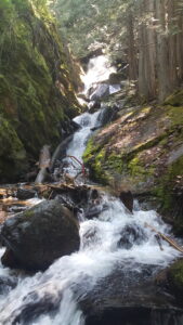 many different trails, how to find them and their levels. We will start with beginner, or the easier hikes, and move through intermediate and advanced.
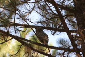 On all of the beautiful walks we will take you, nature shows you some of the most amazing places you’ll ever see. Not only will you experience the beauty but also all the amazing wildlife that calls this land home as well. Not only does that include land animals such as elk, moose, mountain loins and bear, but also birds and fish. Since we are in the Kootenai National Forest all of our lakes and rivers, including the hidden ones, have a vast number of fish. Including cutthroat, bull and rainbow trout as well as big mouth bass and salmon. With our 2.2 million acres of forest comes 223 species of birds calling this place home including the majestic Bald Eagle, northern Hawk-Owl, osprey and great blue heron.
So come explore our world with us!!!!
Beginner:
- Savage Falls- 3 miles up highway 56, turn onto falls creek road fallow to the end. Lakeside residents marvel the view of a waterfall emerging from the mountains. Less then 1 mile from your car to the falls and back, the wonderful wetlands you can explore will lead you right to the falls. If you are as over come by the beauty of this place as I am, there is even a trail straight up the mountain to see the top of the falls. But be warned, the trail to the top of the falls is NOT for the weak, it is a tail made by mountain goats and deer.
- Callahan Creek- Located 1 mile up Callahan Creek Rd. in Troy. This 2 mile trail follows the old railroad that
 was once used for mining and logging the area back in the early 1900s. There is beautiful views of King Mountain and Callahan Creek Canyon. If you are lucky enough to find your way there is also an old mine located at the end of the railroad and trail.
- Little North Fork Falls- From Rexford, travel south 7 miles to Koocanusa bridge, cross and continue south to road 336. Follow 1 mile to the marked trail. A very short 0.5 mile trail that ends in a rain-forest type gorge. An easy to slightly moderate climb offers a view of the waterfall as it enters the gorge and drops into Little North Fork Creek. Some people have described their trip to the falls as being enveloped in time as it gives one the impression of time standing still.
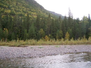
- Logan Park- Located 45 miles west of Kalispell on hwy. 2. The campground offers tent and trailer sites, restrooms and drinking water. With frontage on the north shore of Middle Thompson Lake, Logan is heavily forested with western larch, Douglas-fir, and ponderosa pine. A channel connects Upper, Middle and Lower Thompson lakes. Attractions include swimming, boating, camping, horseshoe pit, water skiing, and good fishing.
Intermediate:
- Quartz Mountain- From highway 37 turn onto Kootenai river road, from there turn right onto Quartz/ Creek road. The first 3 miles of the trail will take you on an adventure from the creek bottom of West Fork Quartz Creek, over the south shoulder of Huson Peek, to the junction of Quartz Mountain trail and the Skyline Trail system. You’ll then follow, for an additional 2 miles, an abandoned logging road that will take you to the summit of Quartz Mountain. The meadows you’ll encounter on the top third of our adventure show you the entire Quartz Creek valley in all its wonder. Great area for huckleberry picking.
- Old HY. 2- Located across the highway from the Kootenai Falls. A roughly 2.3 mile trail that was part of the
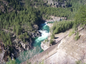 old highway between Libby and Troy. The trail passes through the closed environment of softwoods and mosses, as well as the open environment of wildflowers and alders. This radiant walk will tantalize your every sense. Here you can feel and taste the moister in the air, see and hear the symphonies of mother nature and smell the many breath taking flowers. There are many small springs and cascades through this wonderland of green. If you are looking for spectacular views of the Kootenai River this is where you’ll find it!!
- Devil’s Club- From MT Hwy 56 milepost 8, turn east onto FSR 407 and travel approximately 8 miles to the end of the road and the trailhead. Devil’s Club Trail travels the end of the North Fork of Bull River basin below Dad Peak. Stunning views of Cabinet Mountains Wilderness peaks can be seen from the trail. The trail “ends” at the old Dad Peak lookout site to the south of Dad Peak. Dad Peak Trail continues downhill to the west with a couple primitive campsites found on the ridgeline below Dad Peak. Devil’s Club Trail crosses Devil’s Club Creek and the North Fork of the Bull River both crossings can be challenging and dangerous during high runoff.
- Rock Lake- Is a 8 mile in and out trail located near Trout Creek, Montana. It features a lake and a beautiful forest. The trail offers a number of activity options and is best used from June until October. Bears have been seen in this area so you will want to use caution, make smart food choices, and bring bear spray. The hike from the beginning of the trail head to the waterfall is a relatively easy hike with smooth paths, easy inclines, and nothing daunting for the casual hiker. The hike from the waterfall to the lake is a bit more challenging. About 22 yards from the waterfall, there is a trail heading eastward up the mountain. You might miss it at first, because you are looking at the AWESOME waterfall ahead. The trail is a switchback with some considerable elevation gain from the waterfall to the lake. The views from this point on are just amazing! The lake and surrounding mountains are stunningly beautiful. Along the way there are some fun water crossings including a great bridge. There are some amazing views along the way and a nice waterfall. Also be sure to check out the old mine next to the waterfall on your way up. There is a nice campground when you reach the lake, but there is also a second camping area at the opposite end of the lake. To get there you have to cross the stream that empties out of the lake and follows around the lake to the second camp ground. This camping spot is great and a little more protected if the weather is bad. Also, bring some fishing gear and you’ll be able to catch some nice cutthroats for dinner!
- Spar Peak- is a 7.3 mile out and back trail located near Troy, Montana. It features a river and the wonder of nature. The trail is primarily used for hiking and nature trips.
Advanced:
- Flower Creek- Follow Snowshoe rd. then turn right on Granite Creek rd. and procced about 1 mile. Take Flower Creek rd. until you reach the trailhead. There is many good flats through this 6 mile trail that make great camping areas for families with children. They are in close range of the trail and also the Creek for some summer fun. For the first 2 miles of Flower Creek Trail is on a south slope above Flower Creek. At about 3 miles, it takes off through a campsite on the left. At about 4.5 miles, Trail 317 forks to the right which leads toward the Cabinet Divide trail and Minor Lake.
- Leigh Lake- Located south of Libby, turn right onto Hoodoo Flats road. Continue tell you come to a fork in the road, take the right, all the way to the end. One of Libby’s most ICONIC trails, is a 2.7 mile short, steep trail that is heavily used as an access point into the Cabinet Mountains Wilderness. You will see some very beautiful sites. Craters, a lake, mountain ranges and of course wildlife. Mountain goats are often seen on the slopes above the lake. No motorized vehicles are permitted on this trail, and no vehicles are allowed within the wilderness boundary. This makes for the perfect place for to become one with your wilder side! the trail has incline and definite rocky areas that you will have to climb at points. They can be a bit slick and something you may want to consider if bringing small children and pets. You will cross some streams/water areas a few times so expect to get your feet a bit wet and muddy. BEAUTIFUL waterfalls that you will walk by along the way up. Snowy patches into early summer once you get closer to the lake.
- Granite Lake- Off Snowshoe Road turn right onto Granite Lake Road, at the end of the road there is a road marked #618. This will take you to the parking area and the trail head. If you’re looking for a challenge with an amazing waterfall and lake as your reward, then this hike is the one for you!! After backpacking through this beautiful 11.2 mile trail you’ll find yourself is a stunning cirque once carved by great glaciers. At the far side of the cirque there is a mesmerizing waterfall, flowing from the mountain top into a fish filled lake. Be sure the wear long sleeves and pants if you can, the trail is full of stinging nettles and other thorny plants. You’ll never be bored on this trail – it’s full of surprises!!
- Wee Lake- From Hwy 2 milepost 8, turn north onto Eastside Road and travel approximately 10.8 miles to Arbo Creek Road. Turn right and follow for a mile to the trailhead. This trail leads to Skyline National Recreation Trail #706. The trail follows an old road bed for about 3.5 miles before entering into Saddle Mountain. The 1991 Arbo fire burned through this area making for a diverse landscape and vegetation. Approximately 4 miles from the trailhead the Wee Lake trail turns south, the lake is 0.8 miles further. Don’t let the name fool you ’cause fishing for cutthroat and rainbow trout can be accomplished in Wee Lake. 🙂
- Roberts Mountain- Troy, turn on Callahan Creek road and follow for approximately 12 miles. Trailhead is on the right and can be hard to find. With almost 4 miles of fairly steep travel through large douglas fir stands and several small clearings this makes for the perfect way to get you’re cardio going and enjoy the beauty of nature. The upper end of the trail was burned in 1996 showing the before and after of a wild fire.
- Cedar Lake- is a 13.5 mile out and back trail located near Libby, Montana that features a lake and is rated as difficult. The trail is primarily used for hiking, trail running, camping, and backpacking and is best used from July until September. Dogs are also able to use this trail but must be kept on leash.
All in One:
- Bighorn Tail- Located at the end of Kootenai River Road just off Hwy 37. This prehistoric trail follows the Kootenai River through old structures and orchards, also bighorn sheep ranges. 4.5 miles of eagles, osprey, river otters, and harlequin ducks with so much more can be seen along this trails many branches. The trail gets more primitive at the end, but with a little adventure in your spirit you’ll soon find yourself passing the Kootenai Falls from the other side of the river and finally at the Swinging Bridge.
- Ross Creek Cedars- Hwy. 56 for 18 miles to the south end of Bull Lake and follow the signs to the parking area. This self guided nature trail, will loop you through an old-growth forest environment. The wide path will lead you past informative signs telling you the history and ecology of the many plant and animals native to the grove. In addition to the giant cedars, that are over 1,000 years old, you will see large specimens of other western trees such as douglas-fir. There are many tails to follow through this mystical forest, just remember to never leave the trail!
- Kootenai Falls- Located on highway 2 just outside Troy, Mt. 0.8 miles of beautiful forest following the Kootenai river. These magnificent falls and bridge are seen in the movies “The River Wild” and “The Revenant.” There are two wonderful paths to take here. One takes you to the falls, where you get to see the radiance of thousands of gallons of water spilling over the sandstone and shale that date back millions of years. While the other leads you to a swinging bridge, originally built during the Great Depression to allow firefighters access the north mountains. After the bridge was destroyed in 1948 during a flood, it was then built atop a pair of concrete piers. Once on the other side of the river you can find many more trails to keep your interest peeked all day!!